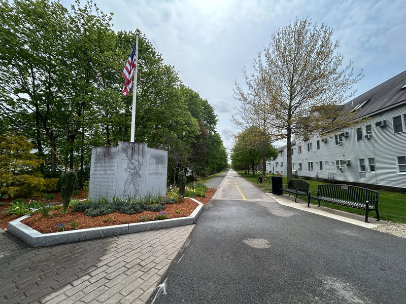
World War II Veterans Memorial Trail
A paved rail trail of about 6.6 miles from downtown Mansfield to Norton, on the rail line that carried soldiers to Camp Myles Standish in World War II. People walk and ride it for flat, easy miles through woods and wetlands, with a short trip from the Mansfield train station.
- Length
- 6.6 mi
- rail trail
- Surface
- Mostly paved
- Get on at
- 4 places
- on the map
From downtown Mansfield to Crane Street lot
Parking at every place to get on · See where
Train back from Mansfield station · Next trains
Open. No closures as of Oct 19, 2026.
Where to get on
Numbers match the list; P has parking.
Download the GPXFor Ride with GPS, Strava, Komoot or a bike computer.
North end, Old Colony Road near East Street, downtown Mansfield
North end of the trail. A side path along Old Colony Road leads toward the train station.
- Mansfield commuter rail station (Providence/Stoughton Line), about half a mile north along Old Colony Road
- Public parking in downtown Mansfield on Old Colony Road.
Fruit Street lots, Mansfield
Just past Mansfield Municipal Airport. Near the short unpaved stretch.
- Two small trail lots at Fruit Street.
Cobb Street lot, Norton
Here the trail leaves the old rail bed and follows Cobb Street and North Washington Street to cross over I-495 on a separated bike lane.
- Small trail lot (about 91 Cobb Street).
Crane Street lot, Norton (south end)
South end of the trail. The old rail bed goes on south but is not built.
- Small trail lot at the Crane Street end.
Getting there
- By transit
- Take the MBTA Providence/Stoughton Line to Mansfield station, then go about half a mile south along Old Colony Road to the trail's north end.
- Parking
- Small free lots at Fruit Street (Mansfield), Cobb Street and Crane Street (Norton), plus public parking in downtown Mansfield.
MoreLess
TrailLink also lists a lot at the Winthrop Dahl Nature Preserve on North Washington Street in Norton.
Ride out, train home
Ride the trail one way and take the Commuter Rail back. Mansfield station is 0.4 miles from the trail's north end.
A roam on this trail
A roam is a self-guided route with stops along the way. The free Shift app checks you in at each stop, and you unlock a badge at the end.
The whole trail
WWII Veterans Memorial Trail
From a WWII staging ground to protected wetlands and rare cedar swamps
3.4 mi 22 minIn the Shift app
Get Shift, free. Follow a roam with turn-by-turn directions to each stop, and see closures on your trails before you go.


About the World War II Veterans Memorial Trail
- Surface
- Paved, except a short unpaved piece near Mansfield Municipal Airport (left unpaved because of conservation rules). A stone dust path runs next to the paved trail in part of Mansfield.
- Rules
- The Friends group says the trail is open to horseback riders, cyclists, walkers and runners.
- Food
- Downtown Mansfield, at the north end.
- Who looks after it
- Towns of Mansfield and Norton (each town's section), with help from the Friends of the WWII Veterans Memorial Trail
- Also called
- Norton Rail Trail, Norton Rail-Trail, WWII Veterans Memorial Trail, WW2 Rail Trail, Mansfield rail trail
More about the trail
- Official page · masstrails10.org
- Friends of the trail · ww2railtrail.org
Where these facts come fromChecked Oct 19, 2026
- traillink.com/trail/world-war-ii-veterans-memorial-trailnorton-rail-trail
- masstrails10.org/wwii-veterans-trail.html
- ww2railtrail.org
- ww2railtrail.org/friends
- bikeitorhikeit.org/ww_ll_veterans_memorial_trail.htm
- travel.yahoo.com/guides/articles/wwii-veterans-memorial-trail-mansfield-090431331.html
- mass.gov/event/norton-nortonmansfield-rail-trail-extension-project-in-nortonmansfield-08-15-2019
- beta-inc.com/project/norton-mansfield-rail-trail-extension
- mass.streetsblog.org/2024/12/30/new-trails-we-can-look-forward-to-in-2025
- railstotrails.org/trailblog/rail-trails-honoring-americas-veterans
- openstreetmap.org/relation/20316035