Marblehead Rail Trail
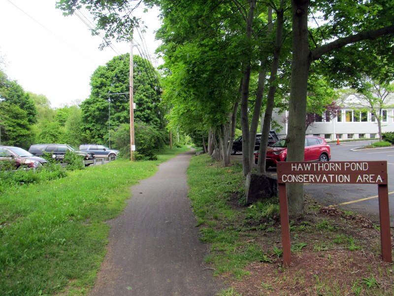
The Marblehead Rail Trail is a flat dirt and stone dust path on two old rail lines that run from Marblehead center to Salem and to Swampscott. People walk, run and ride it through woods, marsh and quiet neighborhoods near the shore.
- Length
- 4.5 mi
- rail trail
- Surface
- Unpaved
- stone dust
- Get on at
- 7 places
- on the map
From Lafayette Street to Bradlee Avenue
Parking at 2 of the 7 places to get on · See where
Open. No closures as of Oct 19, 2026.
Where to get on
Numbers match the list; P has parking.
Download the GPXFor Ride with GPS, Strava, Komoot or a bike computer.
Lafayette Street (Route 114), Salem
West end of the Salem branch. The paved Salem Bike Path (Mayor Anthony V. Salvo path) starts here and runs north past Salem State to Mill Street near downtown Salem. Busy road crossing; use care.
- MBTA bus 455 on Loring Ave (about 600 m). Salem station (Newburyport/Rockport Line) is about 2 miles north via the Salem Bike Path.
- Paid parking near Salem State University, on the Salem Bike Path.
Bessom Street, Marblehead (near Pleasant Street)
Marblehead end of the trail, near the town center. The two branches meet just west of here.
- MBTA bus 441, 442 at Pleasant St @ Bessom St (about 160 m)
Smith Street, Marblehead
South end of the rebuilt Smith to Pleasant Street section (2025).
DirectionsBradlee Avenue, Swampscott
South end of the trail. The last 1,200 feet or so is the Swampscott Rail Trail, built in 2020. Phillips and Preston beaches are about half a mile away.
- MBTA bus 441, 442 at Humphrey St @ Beach Bluff Ave (about 250 m)
- Free street parking on Bradlee Avenue.
Getting there
- By transit
- MBTA buses 441 and 442 run on Humphrey Street and Pleasant Street, close to the Swampscott and Marblehead ends.
MoreLess
Bus 455 runs on Loring Avenue in Salem. From Salem station (Newburyport/Rockport Line), ride the paved Salem Bike Path about 2 miles south to the trail at Lafayette Street.
- Bike share
- Bluebikes stations on the connecting Salem Bike Path: 'Salem State University - Bike Path at Loring Ave' and 'Mayor Salvo Path at Mill St'.
MoreLess
There are none on the Marblehead Rail Trail itself.
- Parking
- Parking is limited. Free street parking on Bradlee Avenue in Swampscott at the south end. Paid parking near Salem State University on the connecting Salem Bike Path.
A roam on this trail
A roam is a self-guided route with stops along the way. The free Shift app checks you in at each stop, and you unlock a badge at the end.
The whole trail
Marblehead Rail Trail
Two historic seaports, tide pools, and a thousand years of stories
5.5 mi 39 minIn the Shift app
Get Shift, free. Follow a roam with turn-by-turn directions to each stop, and see closures on your trails before you go.


Keep going
The Marblehead Rail Trail joins other paths and protected bike lanes. Pick a direction to see it on the map.
This trail Where you can keep going Other bike paths
About the Marblehead Rail Trail
- Surface
- Mostly hard-packed dirt and stone dust, with muddy spots after rain. A 650-foot section between Smith and Pleasant streets was rebuilt in 2025 with crushed aggregate, 11 feet wide. The short Swampscott piece is crushed stone. The Salem Bike Path that connects at Lafayette Street is paved.
- Rules
- Dogs must be on a leash everywhere in Marblehead, including the rail trails (Town of Marblehead Animal Control notice).
- Who looks after it
- Town of Marblehead (Department of Community Development and Planning). The short Swampscott section belongs to the Town of Swampscott.
- Also called
- Marblehead Rail-Trail, The Path, Marblehead Rail Trails, Swampscott Rail Trail, Salem Branch, Swampscott Branch
More about the trail
- Official page · marbleheadma.gov
Where these facts come fromChecked Oct 19, 2026
- marbleheadma.gov/rail-trail-project
- marbleheadweeklynews.com/state-awards-marblehead-718k-for-rail-trail
- marbleheadcurrent.org/2026/09/17/conservancy-airs-concerns-as-rail-trail-work-advances
- marbleheadcurrent.org/2025/09/02/rail-trail-ribbon-cutting-marks-milestone-in-years-long-project
- marbleheadma.gov/rail-trail-work-notice-august-24-28-august-31-september-1
- marbleheadma.gov/wp-content/uploads/2025/07/Notice-of-Rail-Trail-Detour-Clifton-to-Rockaway.pdf
- marblehead.org/node/97306
- trailspotting.com/2022/12/marblehead-salem-rail-trails-ma.html
- traillink.com/trail/marblehead-rail-trail
- traillink.com/trail/salem-bike-path
- hwy.massdot.state.ma.us/ProjectInfo/Main.asp
- swampscottrailtrail.org/latest-news
- gbfs.bluebikes.com/gbfs/en/station_information.json
- api-v3.mbta.com/stops
- https://www.openstreetmap.org (Overpass API, Marblehead Rail Trail, Swampscott Rail Trail, Mayor Anthony Salvo Bike Path ways)