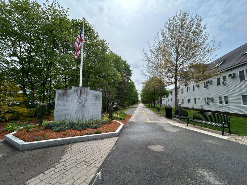
World War II Veterans Memorial Trail
A paved rail trail of about 6.6 miles from downtown Mansfield to Norton, on the rail line that carried soldiers to Camp Myles Standish in World War II. People walk and ride it for flat, easy miles through woods and wetlands, with a short trip from the Mansfield train station.
- Distância
- 6.6 mi
- rail trail
- Piso
- Quase todo pavimentado
- Onde entrar
- 4 lugares
- no mapa
De downtown Mansfield a Crane Street lot
Estacionamento em todos os lugares para entrar · Ver onde
Trem de volta da estação Mansfield · Próximos trens
Aberta. Sem interdições em 19 de out. de 2026.
Onde entrar
Os números correspondem à lista; P tem estacionamento.
Baixar o GPXPara Ride with GPS, Strava, Komoot ou um ciclocomputador.
North end, Old Colony Road near East Street, downtown Mansfield
North end of the trail. A side path along Old Colony Road leads toward the train station.
- Mansfield commuter rail station (Providence/Stoughton Line), about half a mile north along Old Colony Road
- Public parking in downtown Mansfield on Old Colony Road.
Fruit Street lots, Mansfield
Just past Mansfield Municipal Airport. Near the short unpaved stretch.
- Two small trail lots at Fruit Street.
Cobb Street lot, Norton
Here the trail leaves the old rail bed and follows Cobb Street and North Washington Street to cross over I-495 on a separated bike lane.
- Small trail lot (about 91 Cobb Street).
Crane Street lot, Norton (south end)
South end of the trail. The old rail bed goes on south but is not built.
- Small trail lot at the Crane Street end.
Como chegar
- De transporte público
- Take the MBTA Providence/Stoughton Line to Mansfield station, then go about half a mile south along Old Colony Road to the trail's north end.
- Estacionamento
- Small free lots at Fruit Street (Mansfield), Cobb Street and Crane Street (Norton), plus public parking in downtown Mansfield.
MaisMenos
TrailLink also lists a lot at the Winthrop Dahl Nature Preserve on North Washington Street in Norton.
Ida de bicicleta, volta de trem
Pedale a trilha em um sentido e volte de trem regional. A estação Mansfield fica a 0.4 milhas de the trail's north end.
Um Roam nesta trilha
Um Roam é uma rota autoguiada com paradas pelo caminho. O app gratuito Shift faz seu check-in em cada parada, e no fim você desbloqueia um distintivo.
A trilha inteira
WWII Veterans Memorial Trail
From a WWII staging ground to protected wetlands and rare cedar swamps
3.4 mi 22 minNo app Shift
Baixe o Shift, grátis. Siga um Roam com instruções passo a passo até cada parada e veja as interdições nas suas trilhas antes de sair.


Sobre World War II Veterans Memorial Trail
- Piso
- Paved, except a short unpaved piece near Mansfield Municipal Airport (left unpaved because of conservation rules). A stone dust path runs next to the paved trail in part of Mansfield.
- Regras
- The Friends group says the trail is open to horseback riders, cyclists, walkers and runners.
- Comida
- Downtown Mansfield, at the north end.
- Quem cuida
- Towns of Mansfield and Norton (each town's section), with help from the Friends of the WWII Veterans Memorial Trail
- Também chamada
- Norton Rail Trail, Norton Rail-Trail, WWII Veterans Memorial Trail, WW2 Rail Trail, Mansfield rail trail
Mais sobre a trilha
- Página oficial · masstrails10.org
- Amigos da trilha · ww2railtrail.org
De onde vêm estas informaçõesVerificado em 19 de out. de 2026
- traillink.com/trail/world-war-ii-veterans-memorial-trailnorton-rail-trail
- masstrails10.org/wwii-veterans-trail.html
- ww2railtrail.org
- ww2railtrail.org/friends
- bikeitorhikeit.org/ww_ll_veterans_memorial_trail.htm
- travel.yahoo.com/guides/articles/wwii-veterans-memorial-trail-mansfield-090431331.html
- mass.gov/event/norton-nortonmansfield-rail-trail-extension-project-in-nortonmansfield-08-15-2019
- beta-inc.com/project/norton-mansfield-rail-trail-extension
- mass.streetsblog.org/2024/12/30/new-trails-we-can-look-forward-to-in-2025
- railstotrails.org/trailblog/rail-trails-honoring-americas-veterans
- openstreetmap.org/relation/20316035