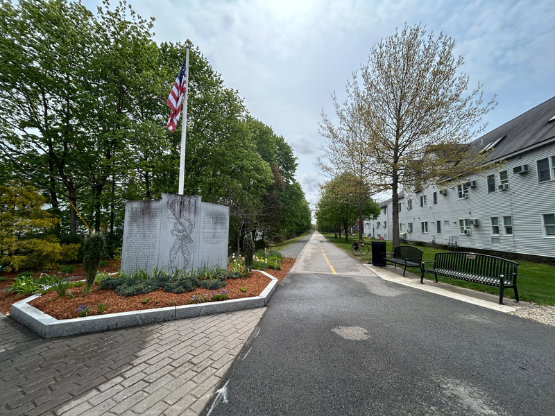
World War II Veterans Memorial Trail
A paved rail trail of about 6.6 miles from downtown Mansfield to Norton, on the rail line that carried soldiers to Camp Myles Standish in World War II. People walk and ride it for flat, easy miles through woods and wetlands, with a short trip from the Mansfield train station.
- Distancia
- 6.6 mi
- rail trail
- Superficie
- Casi toda pavimentada
- Dónde entrar
- 4 lugares
- en el mapa
De downtown Mansfield a Crane Street lot
Estacionamiento en cada lugar para entrar · Ver dónde
Tren de regreso desde la estación Mansfield · Próximos trenes
Abierto. Sin cierres al 19 oct 2026.
Dónde entrar
Los números corresponden a la lista; P tiene estacionamiento.
Descargar el GPXPara Ride with GPS, Strava, Komoot o un ciclocomputador.
North end, Old Colony Road near East Street, downtown Mansfield
North end of the trail. A side path along Old Colony Road leads toward the train station.
- Mansfield commuter rail station (Providence/Stoughton Line), about half a mile north along Old Colony Road
- Public parking in downtown Mansfield on Old Colony Road.
Fruit Street lots, Mansfield
Just past Mansfield Municipal Airport. Near the short unpaved stretch.
- Two small trail lots at Fruit Street.
Cobb Street lot, Norton
Here the trail leaves the old rail bed and follows Cobb Street and North Washington Street to cross over I-495 on a separated bike lane.
- Small trail lot (about 91 Cobb Street).
Crane Street lot, Norton (south end)
South end of the trail. The old rail bed goes on south but is not built.
- Small trail lot at the Crane Street end.
Cómo llegar
- En transporte público
- Take the MBTA Providence/Stoughton Line to Mansfield station, then go about half a mile south along Old Colony Road to the trail's north end.
- Estacionamiento
- Small free lots at Fruit Street (Mansfield), Cobb Street and Crane Street (Norton), plus public parking in downtown Mansfield.
MásMenos
TrailLink also lists a lot at the Winthrop Dahl Nature Preserve on North Washington Street in Norton.
Ida en bici, vuelta en tren
Recorre el sendero en una dirección y regresa en el tren de cercanías. La estación Mansfield está a 0.4 millas de the trail's north end.
Un Roam en este sendero
Un Roam es una ruta autoguiada con paradas en el camino. La app gratuita Shift registra tu llegada a cada parada y al final desbloqueas una insignia.
Todo el sendero
WWII Veterans Memorial Trail
From a WWII staging ground to protected wetlands and rare cedar swamps
3.4 mi 22 minEn la app Shift
Descarga Shift, gratis. Sigue un Roam con indicaciones paso a paso a cada parada y mira los cierres de tus senderos antes de salir.


Sobre World War II Veterans Memorial Trail
- Superficie
- Paved, except a short unpaved piece near Mansfield Municipal Airport (left unpaved because of conservation rules). A stone dust path runs next to the paved trail in part of Mansfield.
- Normas
- The Friends group says the trail is open to horseback riders, cyclists, walkers and runners.
- Comida
- Downtown Mansfield, at the north end.
- Quién lo mantiene
- Towns of Mansfield and Norton (each town's section), with help from the Friends of the WWII Veterans Memorial Trail
- También llamado
- Norton Rail Trail, Norton Rail-Trail, WWII Veterans Memorial Trail, WW2 Rail Trail, Mansfield rail trail
Más sobre el sendero
- Página oficial · masstrails10.org
- Amigos del sendero · ww2railtrail.org
De dónde vienen estos datosRevisado el 19 oct 2026
- traillink.com/trail/world-war-ii-veterans-memorial-trailnorton-rail-trail
- masstrails10.org/wwii-veterans-trail.html
- ww2railtrail.org
- ww2railtrail.org/friends
- bikeitorhikeit.org/ww_ll_veterans_memorial_trail.htm
- travel.yahoo.com/guides/articles/wwii-veterans-memorial-trail-mansfield-090431331.html
- mass.gov/event/norton-nortonmansfield-rail-trail-extension-project-in-nortonmansfield-08-15-2019
- beta-inc.com/project/norton-mansfield-rail-trail-extension
- mass.streetsblog.org/2024/12/30/new-trails-we-can-look-forward-to-in-2025
- railstotrails.org/trailblog/rail-trails-honoring-americas-veterans
- openstreetmap.org/relation/20316035