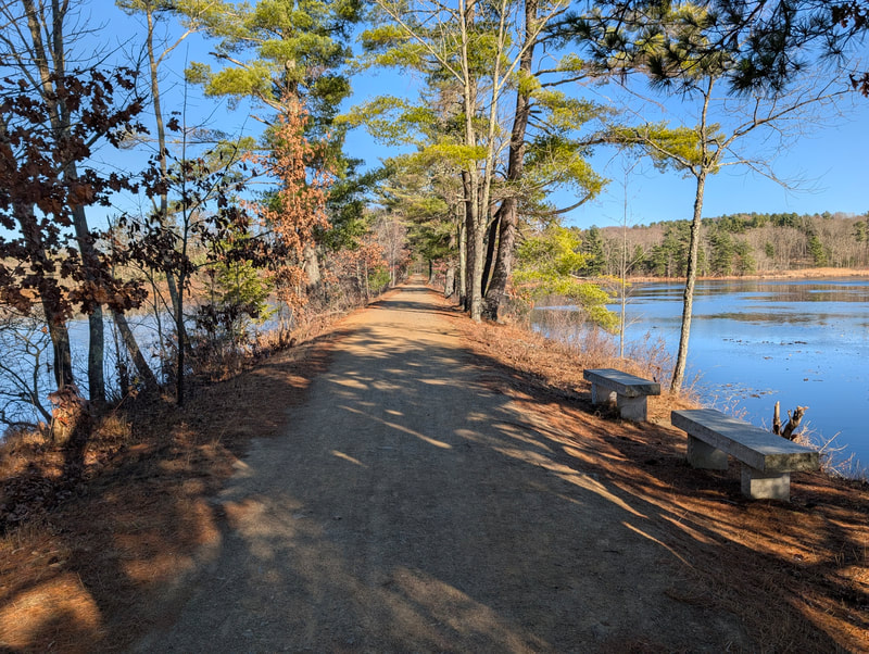
Mass Central Rail Trail
A rail trail that will one day run 104 miles from Boston to Northampton, built in pieces town by town. The paved Wayside section links Waltham to Hudson through quiet woods and wetlands, and the stone dust Wachusett section follows the Quinapoxet River and climbs through Holden and Rutland.
- Distância
- 68 mi
- rail trail
- Piso
- Misto
- pavimentado e de terra
- Onde entrar
- 7 lugares
- no mapa
De Beaver Street a Muddy Pond lot
Estacionamento em 6 dos 7 lugares para entrar · Ver onde
Não é limpa no inverno · Quem limpa
Aberta. Sem interdições em 26 de out. de 2026.
Onde entrar
Os números correspondem à lista; P tem estacionamento.
Baixar o GPXPara Ride with GPS, Strava, Komoot ou um ciclocomputador.
Beaver Street, Waltham (east end of the Wayside section)
East end of the open Wayside trail. Paved. Trail parking in Waltham is very limited.
- MBTA bus 554 stops on Beaver Street at Waverley Oaks Road
Wayland Center, historic Wayland Depot (Route 27)
Cafes, bakeries and shops in Wayland Center next to the trail. The open trail goes on west to Route 20 at Russell's Garden Center, then stops. The gap to Sudbury is about 1.5 miles; use Pelham Island Road and Landham Road.
- Parking near the Wayland Depot and old Wayland station.
South Sudbury, Union Avenue
On the Sudbury to Hudson section that opened July 16, 2026. Coffee shops and food stores about a quarter mile south on a busy road.
- Street parking along Station Avenue.
Hudson, Wilkins Street lot (Assabet River Rail Trail)
West end of the new 7.5-mile Sudbury to Hudson section. Meets the Assabet River Rail Trail here.
- Assabet River Rail Trail parking lot off Wilkins Street.
Thomas Street lot, West Boylston (Oakdale)
East end of a 3-mile stone dust stretch along the Quinapoxet River to River Street in Holden.
- Trail parking lot on Thomas Street. Can fill by mid-morning on summer weekends.
Manning Street lot, Holden
Cross Manning Street at the flashing crosswalk. Year-round accessible portable toilets at the River Street and Mill Street lots nearby.
- Large lot near 200 Manning Street.
Muddy Pond lot, Route 122, Rutland (near the Oakham line)
Start of the Rutland trail guide. The Route 122 lot (about 30 cars, year-round accessible portable toilet) is 1.3 miles east on the trail. Stone dust surface, passes Rutland State Park.
- Lot on the north side of Route 122, with a short ramp to the trail.
Como chegar
- De transporte público
- In Waltham, MBTA bus 554 stops at the Beaver Street end, and Waltham commuter rail station (Fitchburg Line) is about half a mile south of the trail.
MaisMenos
No MBTA service was verified near the Wayland, Sudbury, Hudson or Wachusett sections.
- Estacionamento
- Wayside section: small lots and street parking at Wayland Center, South Sudbury (Station Avenue), Hudson (Wilkins Street lot) and Weston, with very little in Waltham.
MaisMenos
Wachusett section: free lots at Thomas Street (West Boylston), Manning Street, Mill Street and River Street (Holden), and Route 122, Miles Road and Glenwood Road (Rutland).
Roams nesta trilha
Um Roam é uma rota autoguiada com paradas pelo caminho. O app gratuito Shift faz seu check-in em cada parada, e no fim você desbloqueia um distintivo.
A trilha inteira
Wachusett Greenways (Mass Central Rail Trail)
Rock cuts, tunnel murals, and the Quabbin-Wachusett water connection
7.3 mi 48 minNo app Shift
 Photo: Pi.1415926535 / Wikimedia Commons, CC BY-SA 3.0
A trilha inteira
Mass Central Rail Trail: Sudbury to Hudson
Rail history, a rare Pine Barrens ecosystem, and a rebuilt truss bridge
5.4 mi 35 minNo app Shift
Baixe o Shift, grátis. Siga um Roam com instruções passo a passo até cada parada e veja as interdições nas suas trilhas antes de sair.


Continue
Mass Central Rail Trail se liga a outros caminhos e ciclovias protegidas. Escolha uma direção para ver no mapa.
Esta trilha Por onde continuar Outras ciclovias
Sobre Mass Central Rail Trail
- Piso
- Mixed. The Wayside section (Waltham to Hudson) is paved, except about half a mile of stone dust in Wayland between Cochituate Road and Route 20. The Wachusett Greenways sections (West Boylston, Holden, Rutland, Oakham, Barre) are mostly stone dust, with a few short on-road links.
- Regras
- On the DCR-owned Wayside section, dogs must be on a leash (Town of Wayland notice on DCR rules). Rutland State Park charges an entrance fee in summer.
- No inverno
- Not plowed between Waltham and Sudbury; it is left for skiing. Farther west, only the parking lots and entrances are cleared. Fonte
- Condições de todas as trilhas
- Banheiros
- Wachusett section: Wachusett Greenways keeps portable toilets at eight spots in West Boylston, Holden, Rutland and Oakham, including year-round accessible ones at Mill Street and River Street (Holden) and the Route 122 lot and 102 Glenwood Road (Rutland). Rutland State Park also has restrooms. There are none listed on the Wayside section.
- Comida
- Wayland Center (cafes, bakeries, a pub), Russell's Garden Center snacks at Route 20 in Wayland, and food a quarter mile south of the Union Avenue crossing in South Sudbury.
- Quem cuida
- Wayside section: Massachusetts DCR. Wachusett section: built and kept up by Wachusett Greenways (a nonprofit) with the towns and DCR/MWRA landowners. The whole 104-mile route is coordinated by the MCRT Alliance.
- Também chamada
- MCRT, Mass Central Rail Trail Wayside, Wayside Rail Trail, Wayside Trail, Wachusett Greenways rail trail, Central Mass rail trail
Mais sobre a trilha
- Página oficial · masscentralrailtrail.org
- Amigos da trilha · wachusettgreenways.org
De onde vêm estas informaçõesVerificado em 19 de out. de 2026
- masscentralrailtrail.org/completing-the-mcrt
- masscentralrailtrail.org
- masscentralrailtrail.org/current-mcrt-projects
- masscentralrailtrail.org/mcrt-2025-recap
- masscentralrailtrail.org/sudbury
- masscentralrailtrail.org/wayland
- masscentralrailtrail.org/waltham
- masscentralrailtrail.org/holden
- masscentralrailtrail.org/rutland
- masscentralrailtrail.org/barre
- wachusettgreenways.org
- yahoo.com/news/us/articles/mass-gets-7-5-miles-175515805.html
- waylandpost.org/news/mass-central-rail-trail-more-to-come
- 128bc.org/news/good-news-for-walkers-and-cyclists-linden-street-bridge-reopens
- en.wikipedia.org/wiki/Mass_Central_Rail_Trail
- en.wikipedia.org/wiki/Mass_Central_Rail_Trail%E2%80%94Wayside
- mtbproject.com/trail/5926199/mass-central-rail-trail-west-boylston-to-holden
- wayland.ma.us/node/35053
- gbfs.bluebikes.com/gbfs/en/station_information.json
- api-v3.mbta.com/stops
- openstreetmap.org/relation/6674358